On my countless trips between Fredonia, NY (outside of Buffalo), where I was an artist, professor and a fly fishing guide, and Gloucester, MA, where my wife grew up, we would take many side trips to this area for meetings at Orvis headquarters, to visit museums, to visit our son in Middlebury, and to stop at the river.
Over the decades, I would hear many stories about the Battenkill: the historical significance of the river, the challenges it was facing, its fickleness, the size of the fish, and its productivity or lack of. The thread that tied all of the discussions together was how much each individual adored the stream. The river had a personality of its own and many had spent much of their lives trying to understand its nuances. Although it was common to have fishless days wading in her waters, they kept returning because of those special days when they were rewarded with exceptional experiences that created lifelong memories. The anglers felt as though she had relinquished one of her treasures to them and they bonded over time.
My personal connection to the river came through the process of:
- listening and observing the river as I fished, drew, and photographed,
- catching, holding, and releasing fish,
- researching the history of the river,
-experiencing the passion for the river as shared by Cynthia Browning, Bill Bullock, Drew Nisbet, Martin and Valerie Oakland, Peter Hetko, and Tom Rosenbauer,
-translating those experiences into this installation through drawing, painting, video, and sound.
The number of publications written about the Battenkill is a reflection of its rich history and the complexity of its ecology. In this installation, I have concentrated my efforts on a few aspects of the river that I experienced and a few others that might not be well known.
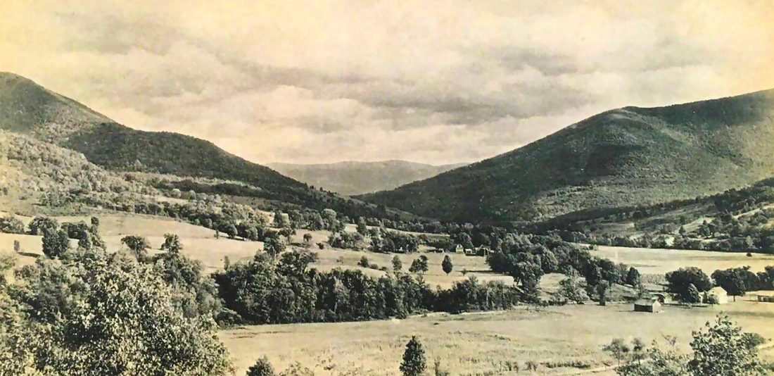
Let’s start at the beginning. Glacial erosion and plate tectonics created the Vermont Valley that the Battenkill flows through as well as the mountain ranges that border it. Continents float like islands on the Earth's molten core and about a billion years ago, continental collisions formed the Taconic and Green Mountain ranges of the Upper Battenkill region. Each range, although very different in its construction, are similar in height with Mount Equinox at 3,816 feet being the highest point of the Taconic Mountains to the west and Stratton Mountain at 3,936 feet being the highest point of Green Mountains to the east. A retreating glacier gouged out the relatively flat valley the Battenkill flows through.
The streams that flow into the Battenkill from these mountain ranges differ dramatically. The Green Mountains' streams, on the east, discharge warmer water in the summer that is nutrient-poor, acidic, and tea-colored from decaying plant matter. These mountains, created by extreme heat and pressure, are made from the oldest known and hardest metamorphic rock in the world. Streams like Bourn Brook, shown in this exhibition, have these characteristics. The steep mountainside that borders the eastern edge of the Battenkill has narrow ravines with streams like the Roaring Branch River, also depicted in this exhibition. These streams have severe vertical drops up to 800 feet in a mile before leveling off in the upper reaches where some good brook trout fishing can be found. Large quartzite boulders appear throughout these streams. The boulders are brittle and break down during the regular high water events that occur with snowmelt and heavy rain. Ultimately, they become the smooth tan stones and gravel that line the bottom of the Battenkill’s streambed.
The western side of the valley is lined by the Taconic Mountains, made out of limestone, dolostone, and marble. Its spring water provides a consistent flow of cold water to the river throughout the summer. The Battenkill also flows over layers of this same rock stratus, which was created by small organisms when the valley was a shallow sea around 430 millions years ago. The softer, more soluble limestone helps to neutralize the acidity of the water coming from the Green Mountains. Consequently, the West Branch of the Battenkill has less acidity than that of the East Branch.
In some parts of this region, these layers became compressed by heat and pressure over time, forming marble. In 1785, the country’s first marble quarry began operations in Dorset near the West Branch of the Battenkill. Due to this unique blending of elements, the Battenkill’s chemistry is on par with some of the most productive trout streams in the world.
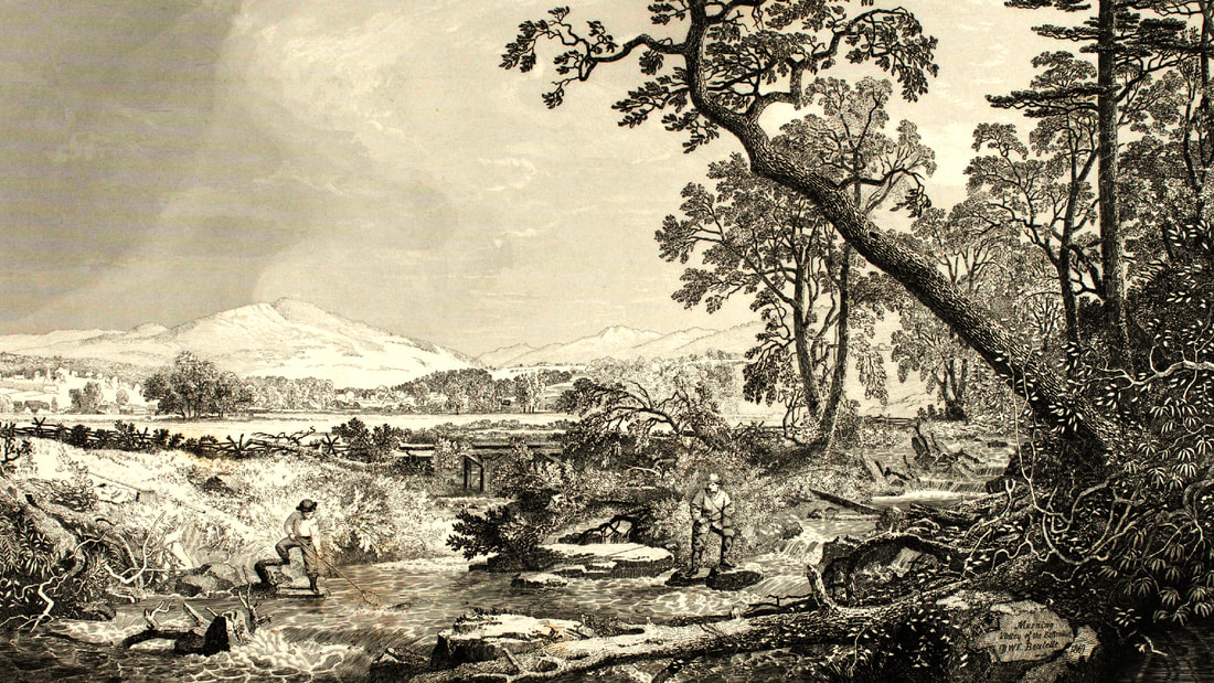
Morning in the Valley of the Battenkill, Vermont 1870 John Sartain (American (born England), 1808–1897) After a painting by Dewitt Clinton Boutelle (American, 1820–1884)
Chemistry, however, is not the only factor that contributes to the health of a productive fishery. Stream improvement and providing more habitat for fish can increase the population by 500 percent. Providing vegetation, which serves as buffers along the stream, can also help mitigate runoff from farms and commercial areas, which often contain pollutants, phosphates, and warm water. Providing awareness of these factors to the public and policy makers can help protect local bodies of water and nurture these natural assets. The efforts from the Battenkill Watershed Alliance, Trout Unlimited Clearwater, Trout Unlimited Adirondack, Trout Unlimited Southwestern Vermont, and Battenkill Conservancy have been instrumental in improving the quality of the river and its fishery.
After the formation of the mountain ranges and retreat of the glacier, brook trout found their way into the region. Although brook trout are part of the Char genus, they are the only trout-like species native to the Battenkill and to the eastern part of the United States. Other species found in the stream were introduced by people rather than occurring naturally. For example, brown trout were brought over from Germany in the 1920s, and rainbow trout were brought from the Pacific Coast in the late 1870’s.
Scientists believe brook trout arrived to the region shortly after the glacial retreat around 14,000 years ago through the Hudson River or from the north through Lake Champlain. Due to the cold spring water from the Taconic Mountains that often bubbles up from underneath the river, the Battenkill is one the largest rivers where brook trout live south of Maine. However, modern populations of brook trout in the region are not as diverse, do not live as long (3 years), or grow as large as those documented a few centuries ago. This decline is due to environmental issues and the eradication of certain genetic strains due to overfishing.
Around the time that the first brook trout were swimming in the valley’s waters, paleo-Indians returned to the same region that would later become the homeland for the Mohicans and Abenaki tribes. Indigenous people lived in the Battenkill region for over 8,000 years before the first white settlers appeared. These were small groups of hunters that followed caribou and other large game that congregated in the narrow valley of the upper Battenkill. Evidence of their weapons and tools have been found throughout the valley. An early style fishing hook dating to 6,000 years ago was actually found just north of Manchester, VT. Through this cultural object, we can ascertain that the first anglers fished for brook trout in the valley at least that long ago. As the climate warmed and stabilized, further archeological evidence indicates activities such as hunting for moose and fruit and nut gathering around 500 AD.
The first contact with Europeans occurred in the 1500s. For this reason, some people prefer indicating whether a cultural object was “pre-contact” or “post contact.” For Native Americans in the Northeast and across the country, this interaction put into motion many changes that negatively affected their culture and well-being for future generations. For example, European contact brought epidemics of smallpox and diphtheria; Native Americans had no immunity to these and other diseases.
200 years later, the population of these First Peoples in New England and across the country had dropped by 90 percent. The 90,000 Native American who lived in New England during the 1500s were more or less replaced, through death and forced relocations, by the same number of European settlers by 1700. Reports by settlers in the late 1700s and early 1800s noted that the population of Native Americans seemed minimal in New England and across the country as a whole. These observations were often used as justification for further expanding white settlements into places that had once been indigenous homelands as well as eradicating indigenous cultural practices.They rationalized that land was not being used but they did not understand that the damage to the Native American population had, for the most part, already occurred by that point.
As the population along the river’s banks changed from Native Americans to European settlers, the river remained an important resource to its residents. The Mohicans called the river Tyetilegogtakook, meaning the “country around the river of toads,” which reflects the omnipresent sounds of mating toads that filled the valley each spring. The European settlers called the river “Battenkill,” which translates as “river of the Dutch.”
As these settlers transformed the land for businesses of agriculture, grazing, manufacturing, and lumber, the river suffered from the effects of clear cutting, pollution, and runoff. Pollution and overfishing devastated the native brook trout population, prompting the introduction of hatchery fish. In 1870, 40,000 brookies were stocked between Manchester and Arlington. Starting in 1930, nonnative fish were introduced, including 7,500 German strain brown trout added to the Green River and 5,550 Scottish strain brown trout added into Battenkill tributaries. Two years later, the main stem of the river received 19,000 browns. The practice continued until the 1970s when stocking stopped and, by 1976, the state decided to manage the river as a wild trout fishery.
Several factors enabled the river to begin to bounce back, including the rise in tourism, the establishment of the Green River National Forest, and the first sewage treatment plant in Manchester. By the 1940s, the river had become one of the premiere fisheries in the country. The ban of DDT in 1972 also improved the quality of the river and fishing since previously the chemical had dramatically affected insect life on the banks and its runoff was a detriment to aquatic biology.
As the stream and fishing improved, the region became a haven for artists, writers, and anglers. Norman Rockwell, Jack Atherton, Meade Schaeffer, and George Hughes—well-known painters and illustrators who created cover illustrations for The Saturday Evening Post—all knew each other through living in the upper Battenkill area. Anna Robertson Moses, a resident and popular artist, also resided in the area. The Bennington Museum has a large collection of Moses’ work. Ogden Pleissner, a famous outdoor sports illustrator and artist, also lived near Bourn Brook until his death in 1983. Prints of his Battenkill paintings were and continue to be sought after by many anglers and residents.
Native Americans from this region continue to practice their crafts and traditions which are deeply connected to water as a fundamental element to life. The Abenaki Arts & Education Center (AAEC) was created as a way of sharing these traditions with the general public and educators.
The upper Battenkill had attracted outdoor writers since the late 1800s, a tradition that continues to this day. Some of these writers include:
The Tyetilegogtakook or Battenkill continues to be a legendary river due to its history, its fishery, its beauty, and to the spiritual vitality it provides to those who are connected to it. This exhibition is my modest artistic interpretation of my connection to it.
As the stream and fishing improved, the region became a haven for artists, writers, and anglers. Norman Rockwell, Jack Atherton, Meade Schaeffer, and George Hughes—well-known painters and illustrators who created cover illustrations for The Saturday Evening Post—all knew each other through living in the upper Battenkill area. Anna Robertson Moses, a resident and popular artist, also resided in the area. The Bennington Museum has a large collection of Moses’ work. Ogden Pleissner, a famous outdoor sports illustrator and artist, also lived near Bourn Brook until his death in 1983. Prints of his Battenkill paintings were and continue to be sought after by many anglers and residents.
Native Americans from this region continue to practice their crafts and traditions which are deeply connected to water as a fundamental element to life. The Abenaki Arts & Education Center (AAEC) was created as a way of sharing these traditions with the general public and educators.
The upper Battenkill had attracted outdoor writers since the late 1800s, a tradition that continues to this day. Some of these writers include:
- George Washington Bethune, editor of the Angler,
- John Harrington Keene, author of Fly Fishing and Fly Making and a regular contributor to the American Angler magazine,
- Lee Wulff, a famous outdoor writer, angler, and film-maker and author of Leaping Silver and Atlantic Salmon,
- Charles Orvis, co-editor of a book on angling antidotes named Fishing with the Fly and owner and founder of the Orvis Company,
- Mary Orvis Mulberry, daughter of Charles Orvis, wrote Favorite Flies and Their Histories,
- Jack Atherton, the previously mentioned artist, also wrote The Fly and the Fish,
- Don Zahner, founder of the Fly Fisherman magazine, moved the headquarters from St. Louis to Dorset; in 1997, the magazine claimed the river was “the toughest brown trout fishery in North America”,
- John Merwin, who started Fly Rod and Reel and Fly-Tackle Dealer magazines and whose book The Battenkill provided valuable insight on my research about the river,
- Craig Woods, author of The River as a Looking Glass,
- Tom Rosenbauer, author of over 20 books, many articles, and has over 12 million downloads of his Orvis podcast, and
- Godffrey Norman, a writer for Field and Stream and co-author of A Sportsman's Life: How I Built Orvis by Mixing Business and Sport.
The Tyetilegogtakook or Battenkill continues to be a legendary river due to its history, its fishery, its beauty, and to the spiritual vitality it provides to those who are connected to it. This exhibition is my modest artistic interpretation of my connection to it.
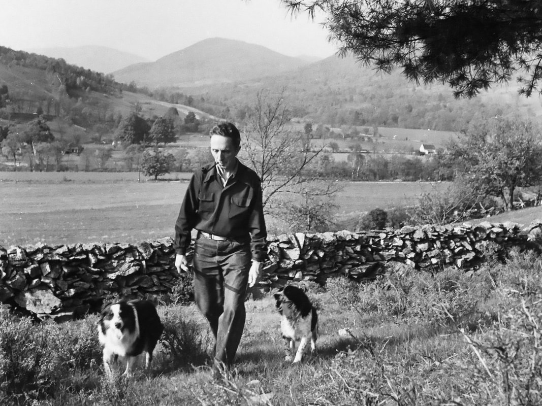
Norman Rockwell near his Arlington, VT. farm in 1950. BETTMANN ARCHIVE